Guide to Belize .info |
|
|
 |
|
||||||||||||||||||||||||||||||||||||||||||||||||||||||||||||||||||||||||||||||||||||||||||||||||||||||||||||||||||||||||||||||||||||||||||||||||||||||||||||||||||||||||||||||||||||||||||||
|
|
In
Belize the temperatures are slightly higher inland, except for the
southern highland plateaus, such as the Mountain Pine Ridge, where it
is noticeably cooler year round. Overall, the seasons are marked more
by differences in humidity and rainfall than in temperature.
The average rainfall in Belize varies considerably, ranging from 1,350 millimeters in the north and west to over 4,500 millimeters in the extreme south. Seasonal differences in rainfall are greatest in the northern and central regions of the country where, between January and April or May, fewer than 100 millimeters of rain fall per month. The dry season is shorter in the south, normally only lasting from February to April. A shorter, less rainy period, known locally as the "little dry," usually occurs in late July or August, after the initial onset of the rainy season. 
|
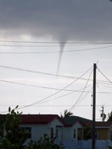
Tropical Depression, Tropical Storm and HurricaneTropical Depression |
A tropical cyclone in which the maximum sustained wind speed is 38 mph or less ( less than 33 kt or 17 m/s). Depressions have a closed circulation. Tropical Storm A tropical cyclone in which the maximum sustained wind speed ranges from 39 mph (34 kt or 18 m/s) to 73 mph (63 kt or 33 m/s). The convection in tropical storms is usually more concentrated near the center with outer rainfall organizing into distinct bands. Hurricane When winds in a tropical cyclone equal or exceed 74 mph (64 kt or 34 m/s) it is called a hurricane. Hurricanes are further designated by categories on the Saffir-Simpson scale. Hurricanes in categories 3, 4, 5 are known as Major Hurricanes or Intense Hurricanes.
|
The Saffir-Simpson Hurricane ScaleThe Saffir-Simpson Hurricane Scale is a
1-5 rating based
on the
hurricane's present intensity. The Saffir-Simpson Hurricane Scale is
used to give an estimate of the
potential property damage and flooding expected along the coast from a
hurricane landfall. |
 Hurricane Mitch close to Belize
Wind speed is the determining factor in
the scale,
as storm surge values are highly dependent on the slope of the
continental shelf in the landfall region. Note that all winds are using
the U.S. 1-minute average. |
Category One Hurricane Winds 74-95 mph (64-82 kt or 119-153 km/hr). Barometric Pressure Above 980 mb (Above 28.94 in) Storm surge generally 4-5 ft above normal. No real damage to building structures. Damage primarily to unanchored mobile homes, shrubbery, and trees. Some damage to poorly constructed signs. Also, some coastal road flooding and minor pier damage. Category Two Hurricane Winds 96-110 mph (83-95 kt or 154-177 km/hr). Barometric Pressure 965-980 mb (28.50-28.94 in) Storm surge generally 6-8 feet above normal. Some roofing material, door, and window damage of buildings. Considerable damage to shrubbery and trees with some trees blown down. Considerable damage to mobile homes, poorly constructed signs, and piers. Coastal and low-lying escape routes flood 2-4 hours before arrival of the hurricane center. Small craft in unprotected anchorages break moorings. Category Three Hurricane Winds 111-130 mph (96-113 kt or 178-209 km/hr). Barometric Pressure 945-965 mb (27.91-28.50 in) Storm surge generally 9-12 ft above normal. Some structural damage to small residences and utility buildings with a minor amount of curtainwall failures. Damage to shrubbery and trees with foliage blown off trees and large trees blown down. Mobile homes and poorly constructed signs are destroyed. Low-lying escape routes are cut by rising water 3-5 hours before arrival of the center of the hurricane. Flooding near the coast destroys smaller structures with larger structures damaged by battering from floating debris. Terrain continuously lower than 5 ft above mean sea level may be flooded inland 8 miles (13 km) or more. Evacuation of low-lying residences with several blocks of the shoreline may be required. Category Four Hurricane Winds 131-155 mph (114-135 kt or 210-249 km/hr). Barometric Pressure 920-945 mb (27.17-27.91 in) Storm surge generally 13-18 ft above normal. More extensive curtainwall failures with some complete roof structure failures on small residences. Shrubs, trees, and all signs are blown down. Complete destruction of mobile homes. Extensive damage to doors and windows. Low-lying escape routes may be cut by rising water 3-5 hours before arrival of the center of the hurricane. Major damage to lower floors of structures near the shore. Terrain lower than 10 ft above sea level may be flooded requiring massive evacuation of residential areas as far inland as 6 miles (10 km). Category Five Hurricane Winds greater than 155 mph (greater than 135 kt or 249 km/hr). Barometric Pressure Below 920 mb (Below 27.17 in) Storm surge generally greater than 18 ft above normal. Complete roof failure on many residences and industrial buildings. Some complete building failures with small utility buildings blown over or away. All shrubs, trees, and signs blown down. Complete destruction of mobile homes. Severe and extensive window and door damage. Low-lying escape routes are cut by rising water 3-5 hours before arrival of the center of the hurricane. Major damage to lower floors of all structures located less than 15 ft above sea level and within 500 yards of the shoreline. Massive evacuation of residential areas on low ground within 5-10 miles (8-16 km) of the shoreline may be required.
|
Belize Hurricane Flags
|
The official
hurricane season in Belize is from 1 June until 30 November. In
addition to radio, tv and internet bulletins, the Belizean hurricane
warning system uses a series of warning flags flown at signal centers
to show the proximity of a tropical storm or hurricane to Belize or its
coastal waters.
Belize Hurricane Preparedness, Rules and SafetyFor hurricane preparedness, rules and safety check our Belize Emergency Page with much useful and actual information.Guide to Belize, June 2020 |
|
|
|||||||||||||||||||||||||||||||||||||||||||||||||||||||||||||||||||||||||||||||||||||||||||||||||||||||||||||||||||||||||||||||||||||||||||||||||||||||||||||||||||||||||||||||||||
©
2002-2025 guidetobelize.info
|
|||||||||||||||||||||||||||||||||||||||||||||||||||||||||||||||||||||||||||||||||||||||||||||||||||||||||||||||||||||||||||||||||||||||||||||||||||||||||||||||||||||||||||||||||||||||||||||