|
|
 |
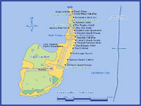
Caye Caulker Map and Guide
|
|
|
|
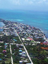
Caye Caulker is a small limestone
coral island off the coast of Belize in the Caribbean Sea measuring
about 5 miles (north to south) by less than 1 mile (east to west). The
town on the island is known by the name Caye Caulker Village, though
the correct name from old maps is Santa Elena.
|
|
Click any Pictures to enlarge
|
|
Some
have said the islands name
is derived from the practice of caulking or sealing the seams in wooden
boats to make them watertight, due to the high number of shipwrights on
the island. "Caye Corker", the alternative spelling of the name used by
British cartographers, has largely fallen into disuse.
The main industry on the island prior to tourism was fishing. The
island sits in the middle of natural migration routes for fish, and
feeding grounds for conch and lobster.
Once on the island, the main mode of transport is simply walking. The
paths are well defined, and crossing the island takes 20 minutes at
most. Bicycles and golf carts are also common and can be rented.
Visitors prone to sunburn should take precautions, as the island is
entirely white coral sand, and reflected sunlight can cause mild
sunburns even in the shade.
There are regular Water
Taxi runs to Caye Caulker from Belize City and San Pedro.
|
|
Attraction
|
|
|
|
This
page will be updated with a new map a new quide and new pictures later
this year. Please come back
|
|
Places Nearby
|
|
|
|
Hol
Chan Marine Reserve
|
|
|
 |
|
|
|
|
Weather
|
|
GTB Weather
|
 |
Quick News
|
|
|
Site
Search
|
|
|
|
|
|
|
|
|