|
|
 |
Punta Gorda Map and Guide
|
|
|
|
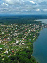
Punta Gorda, known locally as P.G.,
is the southernmost town in Belize and the capital of the Toledo
District. The population is close to 6000 people, with a mixture of
Mopan and Kekchi Maya, Garifuna, Creoles, Lebanese, East Indian and
Chinese peoples.
|
|
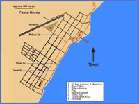
Click any Pictures to enlarge
|
|
Almost
210 miles by road from
Belize City, it is the last sizeable settlement in Southern Belize. The
road into town follows the shoreline; five main streets run parallel
inland. Various fruit trees, especially mango trees, line the streets.
Most small homes are made of wood on stilts.
The town has one hospital, a police station, one bank, a post office, a
gas station, a civic center, a number of churches and schools, and
various grocery stores, hotels, restaurants and bars. Punta Gorda is a
gateway by Water
Taxi to and from Guatemala with immigration and customs office near
the town dock.
|
|
Attraction
|
|
|
|
This
page will be updated with a new map a new quide and new pictures later
this year. Please come back
|
|
Places Nearby
|
|
|
|
|
 |
|
|
|
|
Weather
|
|
GTB Weather
|
 |
Quick News
|
|
|
Site
Search
|
|
|
|
|
|
|
|
|